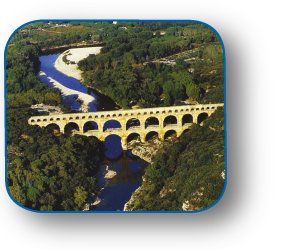
Water and Archaeology
Archaeological sites face an urgent need for scientific studies and specialized consultancy to understand the causes of deterioration and instability and to propose advanced and sustainable engineering solutions for their maintenance and enhancement. The design of such complex interventions requires specialized expertise in various engineering fields, especially when water is the critical element to manage.
IDRAN possesses the multidisciplinary expertise and monitoring tools necessary to understand, prevent, and intervene to protect and enhance both environmentally and naturally significant sites and monuments of historical and cultural interest.

PERMITTING FOR LANDSCAPE AND ARCHAEOLOGICAL RESTRICTIONS
IDRAN provides solutions and expertise to manage the entire workflow required to address permitting challenges due to territorial constraints. Drawing on extensive experience and completed projects in managing and mapping archaeological restrictions, IDRAN has developed a network of university-based expertise to conduct research, studies, and consultancy for feasibility analysis, design, enhancement, and protection of assets and lands subject to landscape and archaeological constraints. These constraints, alongside seismic and hydrogeological factors, represent the main obstacles and delays to social, economic, and industrial development opportunities.
ARCHAEOLOGICAL RISK
Italy holds the world record for UNESCO World Heritage sites. Historic centers like Rome, Florence, and Venice are unique examples of entire cities recognized as extensive archaeological sites to be preserved and enhanced for future generations. The vulnerability of this heritage, coupled with the growing impact of natural disasters, underscores the importance of managing at-risk archaeological sites. This is a crucial area where engineering must identify causes, study dynamics, and propose targeted design solutions for the conservation of archaeological sites and artifacts.
Numerous archaeological sites are at risk due to:
- Hydraulic risks (flooding, mud, and debris flows);
- Hydrogeological and geomorphological risks (subsidence, instability, landslides);
- Seismic risks;
- Chemical-environmental risks (acid rain, pollution, etc.).
IDRAN offers cutting-edge expertise and equipment for archaeological site monitoring, particularly in:
- Detailed topographic surveys conducted on the ground (GPS, laser scanners) and remotely (satellite remote sensing, LiDAR, and drones/UAVs);
- Digital data acquisition, processing, and analysis for 2D and 3D modeling of sites and monuments in both CAD and GIS environments;
- Numerical modeling of physical processes to understand and prevent phenomena associated with hydrogeological risks (software for digital reconstruction of flooding, landslides, etc.).
IDRAN specializes in scientific studies and projects for the maintenance and protection of sites of environmental, naturalistic, historical, and cultural significance, especially when water is the primary critical factor. The company offers specialized solutions and expertise for the design and supervision of interventions to secure archaeological sites and works of historical interest.


